The Zoning Alignment Project (ZAP) A City of Rochester Initiative
What is Zoning?
In the simplest terms, zoning regulates what structures and land may be used for, where a structure may (or must, in certain cases) locate on a lot, and how big that structure can be. It also regulates other elements of site development, such as accessory structures (like sheds and garages), parking, and landscape. Zoning regulations are divided into zoning districts, so that use, bulk, setback and other development regulations can be specifically tailored to the character of each particular zoning district, in alignment with the character of the different places that make up the City of Rochester. (definition quoted from the ZAP website)
What is ZAP?
It stands for Zoning Alignment Project. The City of Rochester is updating City building code and design standards to align with goals and standards in the Rochester 2034 Comprehensive Plan adopted in 2019.
This includes new terminology, per the “Placemaking” concept in the 2034 Plan. For instance R-1 (primarily single-family dwellings) will be called “LDR,” Low-Density Residential; the closest counterpart to C-1, or basic commercial space such as smaller retail or office space, will be “NMU,” Neighborhood Mixed-Use, which also includes residential units, most commonly designed for above the ground floor commercial space.
There are new height guidelines, parking guidelines, and permitted uses pertaining to all of the new Placemaking designations. These components will affect the South Wedge as well as other city neighborhoods. All of the documents, proposals, and presentations can be found at the website www.rochesterzap.com
The South Wedge is an historic neighborhood. The housing stock is old, and streets are narrow, but there is a charm and eccentricity in this tight-knit community. SWPC wants to make sure that the history and character are preserved for residents and businesses now and in the future.
One tenet of the 2034 Plan is encouraging alternate forms of transportation to cars—walking, biking, public transport—and we support reduction in fossil fuel use and the health benefits that come from physical activity. However, efforts toward developing main transportation corridors such as Mount Hope Avenue, South Avenue, and South Clinton Avenue could put a heavy burden on residents of the cross streets with parking, noise, newly permitted businesses and other issues with an influx of people.
At the same time, the City is promoting increased population density to support businesses in the above-mentioned mixed-use development and downtown. The South Wedge is already population-rich. It is a desirable neighborhood, and 30-40 years ago landlords began splitting up single-family homes into multiple units. The result of this is that the homeowner population is decreasing rapidly, now at 24% of the housing units. In one Census Tract within SWPC’s service area, the housing units are at 90% rental. The ZAP proposal includes permitting a single-family house to convert to up to four units if it meets guidelines, as well as a possible garage conversion (which we’ve already seen.) SWPC would like to see more encouragement for neighborhood stabilization and affordable homeownership.
Members of the SWPC Community Engagement Community have been studying the ZAP draft proposals and offering thoughtful comments for consideration to the City Zoning Department, City Council representatives, and the City Planning Commissioners, who are overseeing and approving drafts as they become available. Links to SWPC’s comments, which pertain to the South Wedge area, are below, as are illustrations of examples.
Why is this important to the South Wedge?
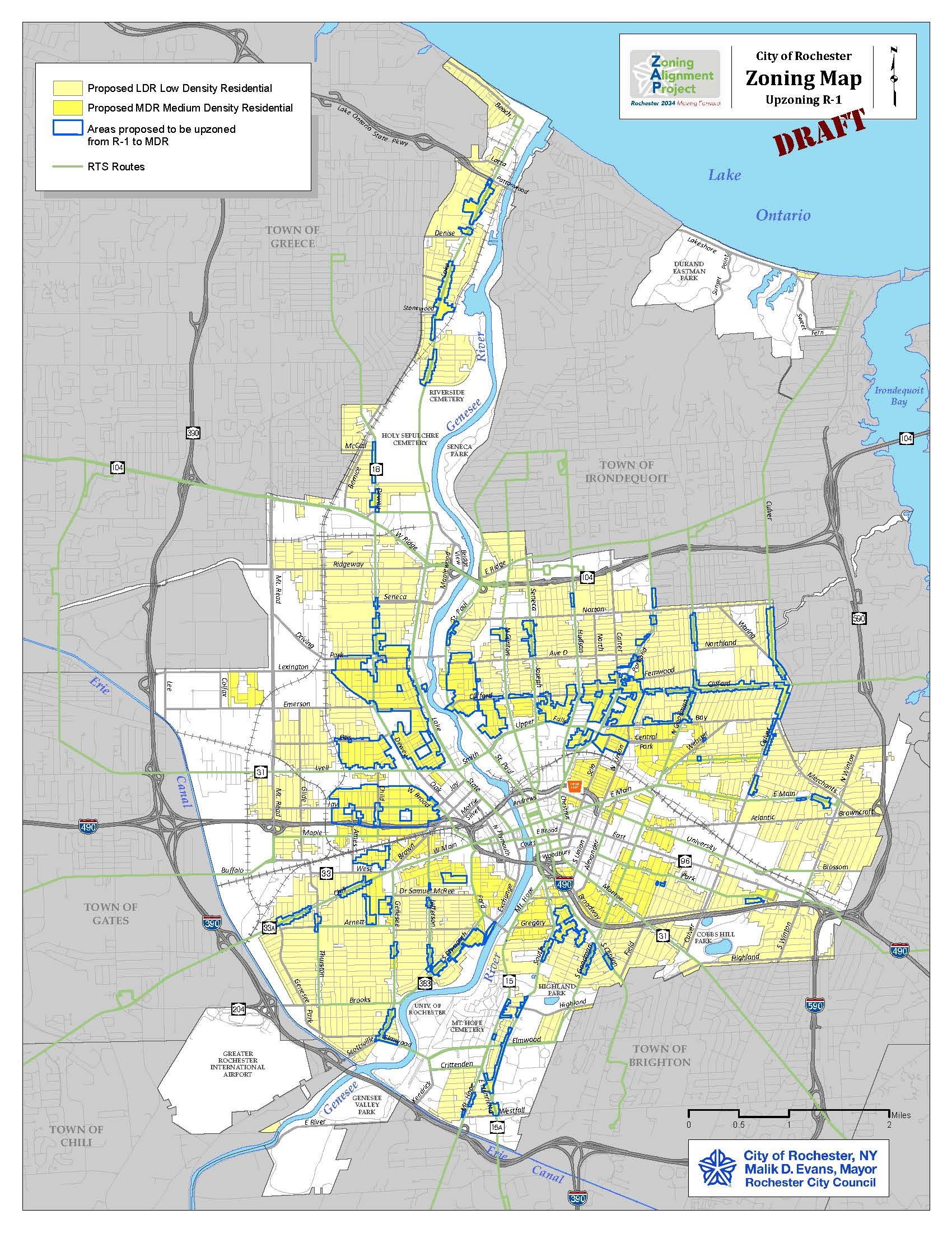
This map illustrates the ZAP proposal to increase density, especially in neighborhoods close to downtown and on main corridors. Areas outlined in blue are R-1 (single-family residential) that will become MDR, Medium-Density Residential (3-4 units residential) if approved. Note the South Wedge area neighborhoods between South Ave. and S. Clinton Ave. that would be affected. Click on the map to enlarge.
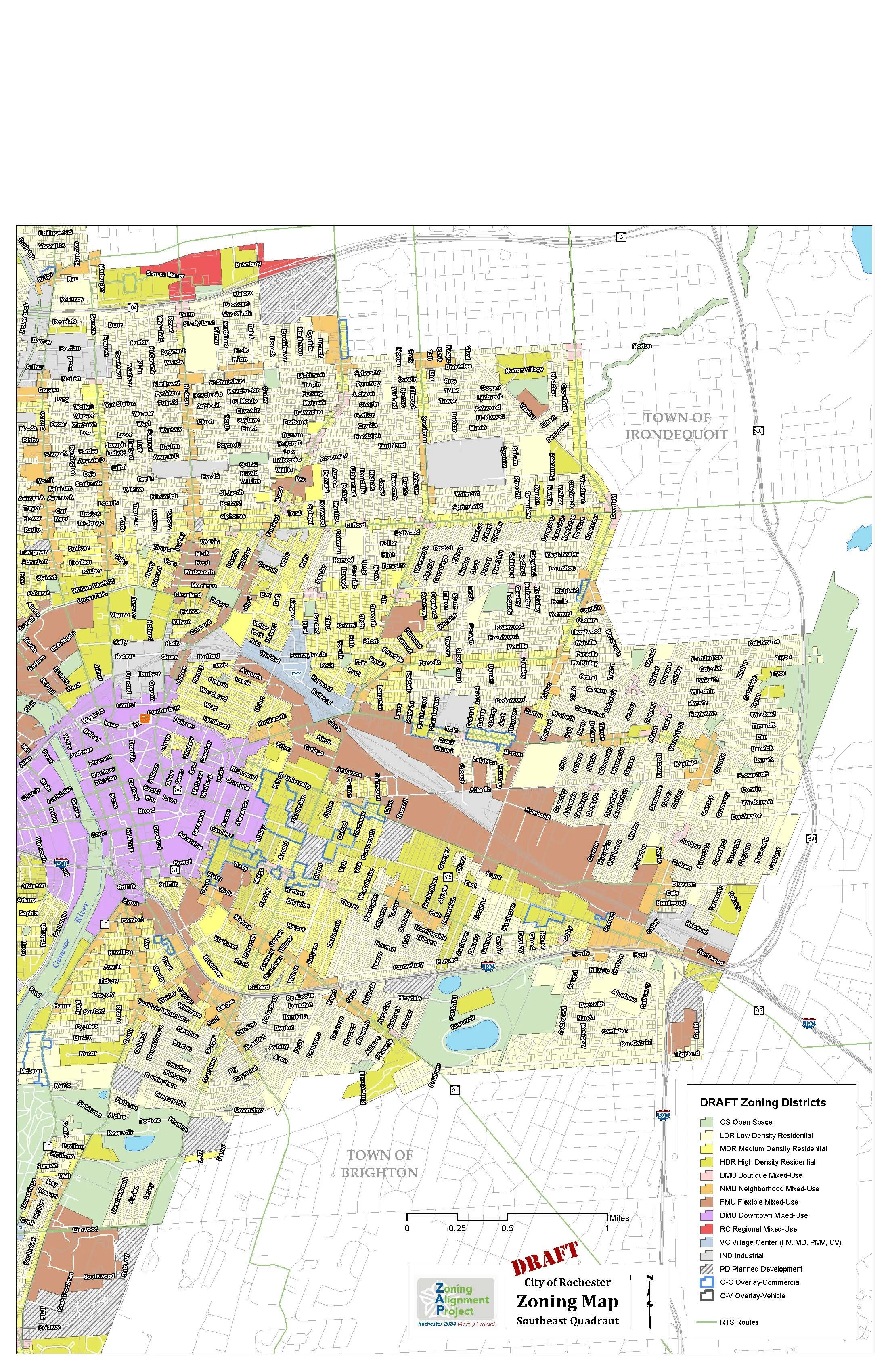
This map illustrates the Placemaking districts in the Southeast Quadrant, as approved in the Rochester 2034 Plan in 2019. Click on the map to enlarge.
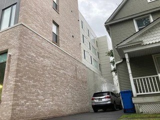
These photos illustrate the importance of smart development, design standards, and integration into older neighborhoods. The building in the top photo is at Mount Hope and Gold St., a project that has no integration to the surrounding Victorian-era residential homes in scale or aesthetics. The bottom photo is in the Park Ave. neighborhood, where homes and this apartment building are closer in scale and design.
Click here for SWPC’s comments to the City for the Round 1 ZAP proposal (April 2022)
Click here for SWPC’s questions & comments to the City on the Round 2 ZAP proposal (July 2022)
Click here for SWPC’s final comments to the City on the Round 2 ZAP proposal (February 2023)
Click here for the latest ZAP Draft (final opportunity for public comments)
Click here for the ZAP Generic Environmental Impact Statement, a summary document (September 2023)
The southeast neighborhoods involved with NBN6 (including the South Wedge) issued a comprehensive document stating pros and cons of elements in the newly released ZAP Draft. These issues affect neighborhoods throughout the city of Rochester. Click here to read it, and please contact us with any questions. Also, the in-person community meetings are listed on our “Upcoming Events” section of this website. These are opportunities to ask questions directly to City Zoning staff. Please attend if you can to get an overview of the ZAP process and new Zoning Code. (November 2023)


